
Categories
Geospatial Data

H3, Geohash and S2: Choosing a Spatial Index

Latitude and longitude are precise, and almost useless as a database index. A pair of floating-point numbers tells you exactly where something is, but answering “what else is near this?” means comparing against every other point you hold. At any real scale, that does not work.

Spatial indexing solves it by giving every location on Earth a cell — a discrete, addressable area with an identifier. Two things in the same cell are near each other by definition, and proximity becomes a lookup instead of a calculation.

Three systems dominate: Geohash, S2 and H3. They are not interchangeable, and the differences show up in exactly the queries you will run most.

What a spatial index actually does

Every system here does the same two jobs. It subdivides the surface of the Earth into cells at multiple resolutions, and it assigns each cell an identifier that encodes where it sits in that hierarchy.

The differences come down to three decisions each system made: the shape of the cell, how the sphere is flattened before subdividing, and how identifiers are ordered.

Those choices sound academic. They determine whether your neighbour queries are symmetric, whether aggregating to a coarser resolution is exact or approximate, and how badly cell sizes drift as you move away from the equator.

Geohash

Geohash recursively divides a latitude/longitude rectangle in half, alternating between the two axes, and encodes the result in base32. Each additional character narrows the box.

The defining property is that a shared prefix means spatial containment. Everything inside gcpuv is inside gcpu. That makes proximity searching possible with nothing more than a string index — a genuine advantage if your data already lives in a relational database.

Where it struggles. Cells are lat/lon rectangles, so they narrow steadily towards the poles — a cell in Oslo covers far less ground than one in Nairobi. Neighbours are also asymmetric: the four edge-adjacent cells are closer than the four diagonal ones, so an unweighted “look at surrounding cells” query is subtly biased.

There is also the boundary problem. Two points metres apart can sit either side of a major subdivision and share almost no prefix, so prefix matching alone will miss genuinely close pairs.

S2

S2, from Google, projects the sphere onto the six faces of a circumscribed cube, then runs a quadtree subdivision on each face. Cells are quadrilaterals, and the projection is chosen to keep area distortion low rather than to keep the maths simple.

Cell identifiers are 64-bit integers ordered along a Hilbert curve, a space-filling curve that keeps points close in space close in sort order. That property is why S2 is comfortable in systems built around sorted integer keys and range scans.

S2 runs from level 0 down to level 30, where cells are roughly a centimetre across. Because it is a true quadtree, nesting is exact: every cell decomposes into precisely four children, and rolling up to a coarser level loses nothing.

Where it struggles. Cells are still quadrilaterals, so the diagonal-neighbour asymmetry remains. And identifiers are opaque — you cannot glance at one and infer anything, unlike a Geohash string.

H3

H3, from Uber, tiles the world in hexagons, based on an icosahedron projection, across 16 resolutions from 0 to 15.

Hexagons have one property that neither rectangles nor quadrilaterals can offer: every neighbour is equidistant. A hexagon has exactly six neighbours, all sharing an edge, all the same distance from the centre. For anything involving movement, spread or flow — how traffic moves between areas, how footfall distributes around a site — that symmetry removes a whole class of distortion.

The trade-off is nesting. Hexagons cannot be subdivided into smaller hexagons exactly. H3’s finer resolutions approximate their parents rather than partitioning them, so aggregating between resolutions is slightly lossy. If you need auditable roll-ups, that matters.

There is also a topological quirk worth knowing before it surprises you: you cannot tile a sphere with hexagons alone. Every H3 resolution contains exactly 12 pentagons, inherited from the icosahedron’s vertices. They sit mostly in the ocean, and most workloads never touch one — but code that assumes six neighbours will eventually meet a cell with five.

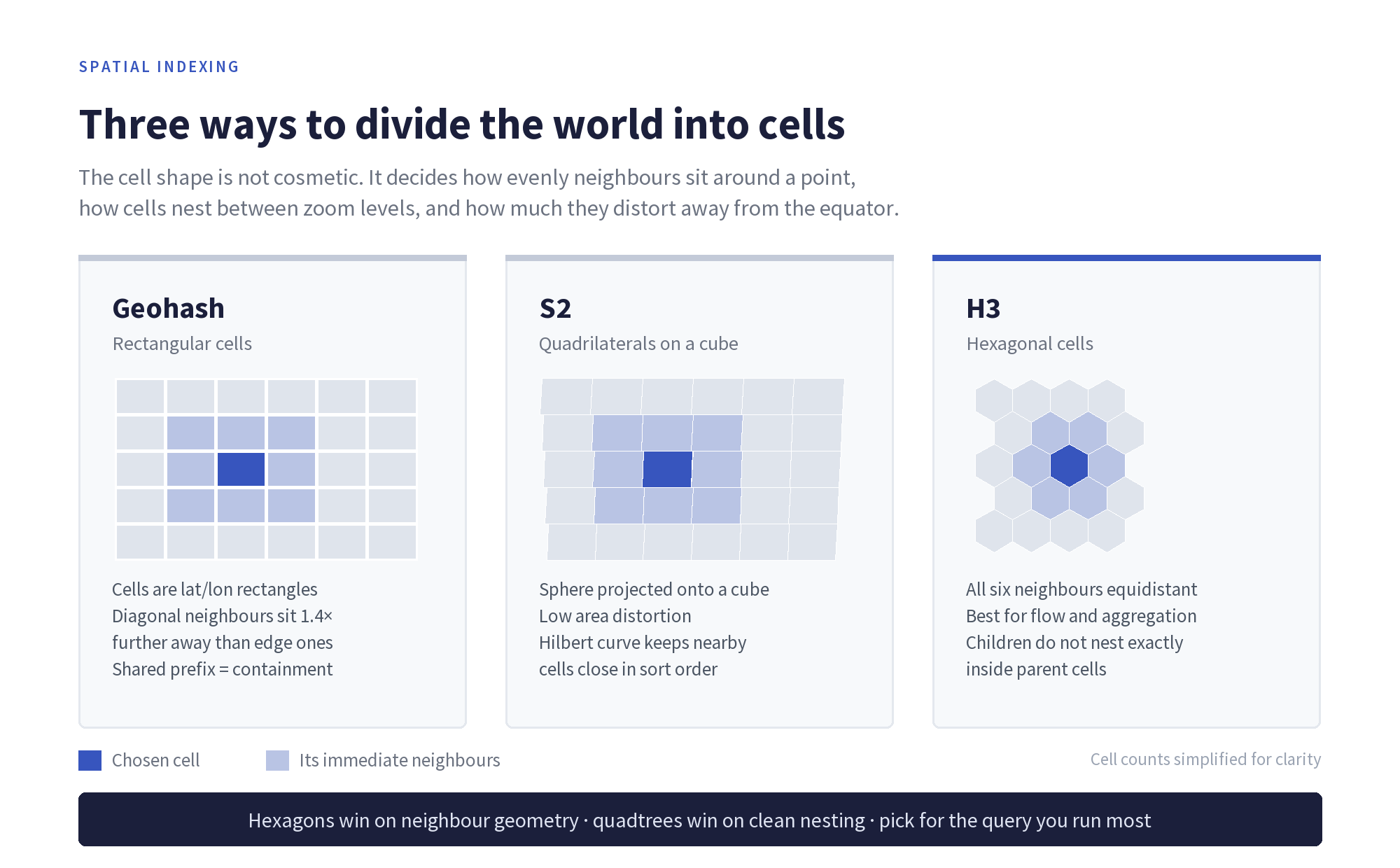
The same chosen cell and its immediate neighbours under each system. The geometry drives the trade-offs.

Compared directly

Geohash S2 H3
Cell shape Lat/lon rectangle Quadrilateral Hexagon (plus 12 pentagons)
Identifier Base32 string 64-bit integer 64-bit integer
Resolutions ~1–12 characters Levels 0–30 Resolutions 0–15
Nesting Exact, prefix-based Exact, four children per cell Approximate
Neighbour symmetry Asymmetric Asymmetric Uniform
Human readable Yes No No
Best at Prefix search in existing databases Region covering and exact roll-ups Aggregation, flow and modelling

How to choose

The question is not which system is best. It is which query you run most.

Choose Geohash when the index has to live inside a database you already have, when a string index is the mechanism available, or when being able to read an identifier and know roughly where it points has operational value.

Choose S2 when you need exact hierarchical aggregation, when you are covering arbitrary polygons with cells, or when your storage layer is built around sorted integer keys and range scans.

Choose H3 when your analysis is about movement and distribution rather than lookup — binning points for heatmaps, modelling flow between areas, or generating features where an uneven neighbourhood would bias the model.

Plenty of production systems use more than one: H3 for analysis and modelling, S2 or Geohash for storage and retrieval. Converting between them means going back to the underlying coordinates, so store those regardless.

Spatial indexing: common questions

What is a spatial index?

A spatial index divides the Earth’s surface into discrete cells, each with an identifier, so that spatial questions become lookups on those identifiers instead of distance calculations across every record.

Why are hexagons used for spatial data?

Because all six neighbours of a hexagon are the same distance from its centre. Square and rectangular grids have edge neighbours and diagonal neighbours at different distances, which biases any analysis of movement or spread.

Why does H3 have pentagons?

Because a sphere cannot be tiled with hexagons alone. H3 is built on an icosahedron, whose 12 vertices each produce a pentagon at every resolution. They are positioned largely over ocean, but code handling H3 cells should not assume six neighbours.

Is H3 more accurate than Geohash?

Neither is more accurate — accuracy comes from the underlying coordinates. They differ in geometry. H3 gives uniform neighbour distances; Geohash gives readable identifiers and prefix containment. The right answer depends on the query.

Can you convert between Geohash, S2 and H3?

Not directly, because the cell boundaries do not align. Conversion goes via latitude and longitude, which means the original coordinates should always be retained rather than only the cell identifier.

Next steps

Choosing an index is downstream of the data itself. A hexagonal grid does not rescue coordinates that were imprecise to begin with, and no cell system compensates for gaps in coverage.

Our guide to raw geospatial and location data covers what to check in the underlying dataset, and our guide to location data explains the data types these indexes are typically applied to.


Categories
Geospatial Data

How Gaming Companies Use Geospatial Data To Serve Their Customers

Geospatial data, also known as geographic data or spatial data, is collected and used more than ever by today’s leading gaming companies to better serve their customers. 

On this page, we will be taking a closer look at how gaming companies use geospatial data to improve their products and/or services and customer experience, why it is so important to modern gaming platforms, and how your location affects the types of promotional offers you see. 

We will also discuss several other ways that iGaming brands use data to personalise content before revealing whether geospatial targeting actually improves the customer experience. 

What Is Geospatial Data and How Is It Collected?

The term geospatial data refers to a broad range of location-specific information, so anything with a geographic component. It can be collected via several means, including drones and satellites (also known as remote sensing), Global Positioning System (GPS), surveys, and aerial photography. 

Examples of geospatial data include satellite imagery, maps, addresses, coordinates, and descriptive attributes (such as population density, land use, and population density). When collected, it can be analysed to reveal patterns and relationships, and to determine precise locations on Earth. 

Why Is Location Data Crucial to Modern Gaming Platforms?

Geospatial data is crucial to modern gaming platforms because it helps operators/business owners provide far more relevant location-based services tailored to individual regions, which can significantly enhance the overall user experience on various levels. 

Besides personalised experience, the gathering of location data and the strategic use of this information are crucial in the following ways:

  • Geospatial location data enables gaming platform operators to deliver geo-targeted advertising campaigns, promotional offers, and in-game purchases, which helps increase revenue
  • It helps to detect and prevent a range of fraudulent activities, such as when players try to access geo-restricted platforms, products, services, and other restricted content using virtual private networks (VPNs)
  • Geospatial data/geo location detection software enables operators to comply with location and international laws and regulations regarding gaming/gambling laws
  • It also helps bolster fair play by detecting and preventing players from cheating in specific games on certain gaming platforms 
  • It helps operators understand player behaviour and how it varies dramatically from one region to another

Additionally, it can help developers optimise how they design levels and how challenging they make those levels, and enables them to tweak and enhance specific in-game features and gameplay mechanics that are popular in certain regions to make the gameplay experience more immersive, engaging, memorable, rewarding, and interactive. 

How Does Your Location Affect What Promotions You See?

Let’s just say that you live in Australia or New Zealand, but want to try a US-focused iGaming platform, you won’t have much luck. However, if you’re a US resident, you’ll notice that finding a FanDuel casino promo code is relatively straightforward. 

If you are searching from Australasia, you won’t be able to use any bonus codes that you find because FanDuel doesn’t yet accept real cash wagers from players living in these two regions. Instead, you should look for a site that accepts real money wagers from players in your region. 

The geospatial data and geo-location software used by the FanDuel operator would reveal that you are based in Oceania, not the US, meaning that although you could access the website, but wouldn’t be able to register an account on this platform because it doesn’t accept players from this region. 

Therefore, you wouldn’t be able to deposit, play any of their games in the real money mode, claim any of their bonuses, or withdraw winnings because the products and services on that platform simply wouldn’t be available to you. 

Even if you tried to mask your true location by using a VPN too to make it appear as though you were in the US, not Australia or New Zealand, their sophisticated VPN-detectors would also reveal that you were using a VPN to sidestep local and international laws, and you would be asked to switch it off, thus revealing your true location. 

Alternatively, you might be able to visit the website from this region, but during the sign-up process, you would be required to enter a US address because FanDuel doesn’t even have Australia or New Zealand address options available in their list of countries on their online registration form. 

Online casino promotions are also targeted to different regions for various reasons, so it’s always best to stick to playing on platforms that specifically cater to people in your region because those promotions will always be far more relevant. 

Are There Other Ways Casinos Personalise Content with Data?

The iGaming industry’s safest online casinos also use various data-gathering AI-powered tools and machine learning technology to personalise the user experience in various other ways. 

For example, artificial intelligence can ‘non-intrusively’ monitor each player’s account to deliver better game suggestions, more rewarding bonuses and promotions that are far more personalized and tailored to the individual, and far better player support and customer service. 

Does Geospatial Targeting Actually Improve Customer Experience?

Yes. Geospatial targeting, especially in the traditional gaming and iGaming sectors, significantly enhances the overall user experience on so many different levels. 

It helps boost user engagement and customer satisfaction and enables operators to deliver more relevant services and products in real-time based on each user’s specific global location. 

Operators can also deliver proactive resolutions to any technical issues players may encounter on their platforms, or provide more relevant answers/solutions to any questions those players may have about their account on that gaming platform. 

By using this data correctly and ensuring that players can only access specific content, operators can improve operational efficiency, reduce costs, and deliver optimised services, giving them a competitive advantage over their rivals. 

Geospatial targeting has become one of the most powerful tools out there for business owners. It allows operators to boost revenue, enhance the user experience, improve customer service, and streamline their day-to-day operations. 


Categories
Geospatial Data

The Power of Geospatial Data: How Location Intelligence is Reshaping Industries

Geospatial data, often referred to as location intelligence, is revolutionizing various industries by providing insights that were previously unattainable. From transportation to urban planning and personal safety, the integration of geospatial information is paving the way for more efficient and secure systems. But how exactly is this data transforming these sectors? And what role does it play in everyday applications, such as parenting apps? Let’s delve into these questions.

Transportation Advancements

The transportation industry has witnessed significant advancements through the application of geospatial data. By analyzing location-based information, transportation agencies can optimize routes, reduce congestion, and enhance safety measures. AI-powered geospatial data helps municipalities identify high-risk areas, allowing for targeted interventions to improve road safety.

Public transit systems also rely on geospatial analytics to monitor real-time vehicle locations, predict arrival times, and inform passengers promptly. This not only improves transit operations but also enhances the commuter experience by reducing wait times and uncertainties. Ride-sharing and logistics companies use geospatial data to refine delivery routes, minimize fuel consumption, and enhance fleet management.

Smart Urban Planning

Urban planners increasingly use geospatial data to design sustainable and resilient cities. By mapping out land use patterns, population densities, and infrastructure layouts, planners make informed decisions that promote efficient resource allocation and

environmental conservation. Geospatial technology allows for detailed visualizations of urban dynamics, facilitating smarter planning for roads, utilities, and public spaces.

Another major benefit is disaster preparedness. Governments and emergency services leverage geospatial data to identify vulnerable areas, develop evacuation plans, and coordinate response efforts. In a world where climate change is causing more frequent natural disasters, having this kind of predictive intelligence is invaluable.

Enhancing Personal Safety

In the realm of personal safety, geospatial data plays a pivotal role in various applications. Law enforcement agencies analyze location intelligence to track crime patterns, deploy resources effectively, and predict potential hotspots. This data-driven approach enhances public safety by enabling timely interventions and more strategic decision-making.

Geospatial technology is also crucial in emergency response. With real-time location information, first responders can reach affected areas quickly, minimizing damage and saving lives. Fire departments use predictive analytics to assess fire risks in different regions, while search-and-rescue teams rely on location tracking to find missing persons faster.

Geospatial Data in Parenting Apps

One of the most personal applications of geospatial data is in parenting apps designed to help families keep their children safe. These apps utilize GPS technology for real-time location tracking, ensuring that parents always know where their children are. Many of these tools include geofencing features, allowing parents to set virtual boundaries and receive instant alerts if their child enters or leaves a designated area.

For example, some apps help parents track iPhone location without needing additional software, making it easier to stay connected and aware of their child’s whereabouts. This technology offers peace of mind, especially in busy urban environments where children may travel alone to school or extracurricular activities. Location-based alerts ensure that parents can respond quickly if their child deviates from a safe path.

Future Prospects of Geospatial Technology

As technology continues to evolve, the integration of geospatial data across various sectors is expected to deepen. In transportation, self-driving cars will rely heavily on precise location intelligence to navigate roads safely. Urban planners will harness more

sophisticated geospatial analytics to create energy-efficient smart cities, where infrastructure and public services adjust dynamically to real-time data.

Personal safety applications will also see significant advancements. Wearable devices may soon integrate geospatial tracking with biometric monitoring, allowing emergency responders to detect distress signals and locate individuals in real-time. The ability to merge AI-driven predictive analytics with geospatial data will lead to even more accurate crime prevention strategies and faster response times.

Parenting apps, too, will benefit from these advancements. As location tracking technology improves, parents will have access to more precise and user-friendly solutions to monitor their children’s movements and enhance overall safety. The future of geospatial technology is not just about knowing where things are—it’s about using that knowledge to create safer, smarter, and more efficient systems across all aspects of life.

Conclusion

The power of geospatial data lies in its ability to transform raw location information into actionable insights. Industries like transportation, urban planning, and personal safety are undergoing major transformations, leading to more efficient, safe, and intelligent systems. As this technology continues to evolve, its applications will only expand, shaping the future of everything from smart cities to family security.

Understanding geospatial data’s potential is crucial, as it directly impacts daily life in ways we may not always recognize. Whether it’s optimizing your commute, improving public safety, or helping parents track their child’s iPhone location effortlessly, geospatial intelligence is becoming an integral part of modern living.

Related: read more about raw geospatial and location data feeds.

Categories
Geospatial Data

The Intersection of Geospatial Data and Cybersecurity: Protecting Location-Based Information in a Digital World

In our increasingly digital society, geospatial data has become integral to various sectors, from marketing and logistics to urban planning and emergency services. Geospatial data refers to information that links geographic locations to specific data points, providing valuable insights about patterns, behaviors, and trends. For businesses, this data offers the potential to enhance customer engagement, optimize operations, and streamline decision-making. In industries like urban planning, it helps shape the future of cities by informing infrastructure development and resource distribution. Meanwhile, emergency services rely on geospatial data to respond swiftly to crises and deploy resources effectively.

However, as valuable as geospatial data is, it also raises significant cybersecurity challenges. With location-based data becoming a goldmine for companies, it also becomes a prime target for cybercriminals. The more businesses and organizations integrate geospatial data into their systems, the more vulnerable they become to cyberattacks. A breach in this data could expose sensitive information, violate privacy, and even put individuals’ physical safety at risk. The rise of tracking applications, for example, introduces an additional layer of complexity, where location-based information can be accessed or misused without consent, leading to unwanted consequences.

As geospatial data continues to grow in importance, securing this information becomes crucial. Protecting location-based data isn’t just a technical necessity but also an ethical responsibility that impacts individuals, businesses, and society as a whole. This article explores the cybersecurity risks associated with geospatial data and provides strategies to mitigate them, ensuring that the benefits of this data can be realized without compromising security.

The Growing Use of Geospatial Data

Marketing: Businesses leverage geospatial data to tailor location-based advertising, enhancing customer engagement and driving sales.

Logistics: Accurate location data optimizes route planning, inventory management, and supply chain efficiency, ensuring timely deliveries and reducing operational costs.

Urban Planning: City planners utilize geospatial data to design infrastructure, plan public services, and manage urban development effectively.

Emergency Services: First responders rely on geospatial data to navigate to incidents swiftly, coordinate disaster response efforts, and allocate resources efficiently.

Types of Sensitive Location-Based Data

Organizations handle various forms of sensitive geospatial data, including:

  • Real-Time Location Tracking: Monitoring the current positions of individuals, vehicles, or assets.
  • Location Histories: Records of past movements and visits to specific places.
  • Geofencing Data: Information about virtual boundaries set around specific geographic areas and alerts when these boundaries are crossed.
  • Proximity Data: Insights into how often and for how long individuals are near particular locations.

Risks of Data Breaches and Consequences of Exposing Geospatial Data

The exposure of geospatial data can lead to several severe consequences:

  • Privacy Violations: Unauthorized access to location data can infringe on individual privacy, revealing personal routines and habits.
  • Physical Safety Threats: Detailed location information can enable malicious actors to track individuals, potentially leading to stalking or physical harm.
  • Financial Losses: Attackers can exploit location data to commit fraud, such as targeting individuals during travel or exploiting location-based promotions.
  • Reputational Damage: Organizations suffering data breaches may face loss of customer trust, negative publicity, and a decline in business.
  • Operational Disruptions: Breaches can lead to system downtimes as organizations work to contain and assess the damage, affecting service delivery and productivity.

It’s important to acknowledge that certain tracking applications, when used ethically and with consent, offer benefits such as:

  • Location Tracking: Ensuring the safety of loved ones or assets by monitoring real-time positions.
  • Employee Productivity Monitoring: Businesses can track employee locations during work hours to optimize operations and ensure safety, provided there is mutual agreement and transparency.
  • Digital Performance Analysis: Assessing how users interact with digital platforms to enhance user experience and engagement, with their consent.

These applications serve positive purposes when used responsibly and transparently. However, without proper safeguards, they can pose significant risks. If you’re interested in learning more about tracking applications, here’s a detailed guide on how certain hidden tracking apps can be used for these purposes when both parties agree.

Securing Geospatial Data: Best Practices

To protect sensitive location-based information, organizations should implement the following measures:

  • Data Encryption: Utilize strong encryption protocols to safeguard geospatial data during storage and transmission, ensuring that unauthorized parties cannot access or decipher the information.
  • Access Controls: Implement strict access controls to limit who can view or modify geospatial data, ensuring that only authorized personnel have access to sensitive information.
  • Regular Audits: Conduct regular security audits and vulnerability assessments to identify and address potential weaknesses in systems handling geospatial data.
  • User Consent and Transparency: Obtain explicit consent from individuals before collecting or sharing their location data, and provide clear information on how their data will be used and protected.
  • Secure Third-Party Integrations: Ensure that any third-party services or applications that access geospatial data adhere to stringent security standards and have appropriate data protection measures in place.
  • Employee Training: Educate employees on the importance of geospatial data security and best practices for handling sensitive information to reduce the risk of human error leading to breaches.

Conclusion

Geospatial data offers immense value across various industries, but its sensitivity necessitates robust cybersecurity measures. By understanding the risks and implementing comprehensive security strategies, organizations can harness the benefits of location-based information while protecting against potential threats. Prioritizing the security of geospatial data is not just a technical requirement but a commitment to safeguarding privacy, ensuring safety, and maintaining trust in our digital interactions.

News Highlight: A recent incident revealed that personal location data of millions was exposed due to inadequate data protection measures, underscoring the critical need for enhanced geospatial data security.

Related: read more about raw geospatial and location data feeds.

Categories
Geospatial Data

Why Businesses Need a Marketplace App Development Company to Leverage Geospatial Insights

It is possible to create your own marketplace in various ways. However, when considering a marketplace builder versus a marketplace app development company, the latter wins in terms of flexibility, precision, and advanced ways of working with geospatial data. Marketplace builders often enable basic geospatial data. These are:

  • calculating delivery costs, 
  • picking a store location, or 
  • basic geo-targeting for marketing. 

With a marketplace app development company, your marketplace can leverage geospatial intelligence. This includes using:

  • integrated advanced geospatial API solutions,
  •  real-time data processing, 
  • geofencing for security alerts and location-based promotions, 
  • and real-time tracking. 

Here is the list of a few marketplaces that  would not have been market giants without custom development for geospatial insight:

  • DoorDash, 
  • UberEats, 
  • Lyft, 
  • Airbnb, 
  • TaskRabbit, and 
  • Doctor-on-Demand.

Let’s dive into the possibilities of custom marketplace app development for leveraging geospatial insight for your marketplace. 

Enhancing Business Strategies with Location-Based Data

Geospatial insight is processed raw data such as city locations in combination with other data layers such as real-time traffic data, environmental conditions, and environmental risks. It is not simply tracking particular geographical data. Geospatial insight means layering different data against geographical locations, interpreting it, and adjusting it based on real-time data.

For instance, in the image below, the layers of data are used for a preventative health app. By combining these different layers of data, a preventative health app can map the highest health risk neighborhoods to a variety of causes and offer tailored solutions for each area. 

Source

In the context of a marketplace app, let’s imagine a home services marketplace. On top of the core geospatial data layer, we’ll require population data such as household density, homeownership data, and age distribution. On top of that, historical data should be layered such as booking data, seasonal trends, and cancellation rates. The next step in forming insight would be combining the traffic & mobility layer as well as socioeconomic data. All in all, these layers together will provide the home services marketplace app with:

  • Ability to predict areas with high demand for services;
  • Optimize dispatching service providers or incentivize them enough to match the demand and ensure the lowest waiting times;
  • Ability to queue jobs in certain areas for maximum efficiency of the service providers;
  • Adjust pricing dynamically to create fairer costs;
  • Create localized marketing.

It is vital to emphasize, that unlocking these features is not possible with any of the marketplace builder solutions. Geospatial insight is a unique, business-specific combination of data internal to the business as well as coming from open-source APIs and paid DaaS (Data as a Service) providers.


According to Veena Muralodharan, a GIS expert, the geospatial insight is a new powerful strategic tool such as:

“LI (Location Intelligence) is creating a new wave of spatial analysis with methods and techniques that focus on solving business problems by embracing open source tools and dynamic data streams.”

How Marketplace Apps Use Geospatial Insights for Competitive Advantage

As shown above, geospatial insight opens up new opportunities. A marketplace app development company can combine layers of data to achieve unique business outcomes. For instance, geospatial insight translates into understanding and determining health-risk areas. That, in turn, allows the company to suggest effective interventions to improve health outcomes and reduce healthcare costs. In the end, it leads to evidence-based and data-informed decision-making. 

In the home services marketplace app example, your app can take balancing demand and supply to the next level. The biggest challenge of most marketplace is balancing demand and supply. With geospatial insight, you will be able to launch a promotion to generate higher demand at a quiet time in a certain location. On the other hand, you will be able to incentivize service providers to take on more jobs. Moreover, you might be able to offer a service provider to accept jobs as a package. For instance, 3 jobs in a remote area. A service provider will get substantial revenue while the system splits the transportation costs and offers customers a fairer price. A marketplace that can consistently keep both parties engaged and satisfied wins in the market.

In the table below, geospatial insight is broken down by features, involved data layers, and business outcomes. The top online marketplace app development company often analyzes the business case individually, and involved data layers may vary.


Feature Data layers on top of the geospatial layer Competitive Advantage
Heatmaps
  • Demographic data
  • Historic demand
  • Consumer behavior patterns
  • Real-time data
  • Determining underserved areas and high-demand zones,
  • Reducing waste, targeted effort
  • Adaptive pricing.
Resource allocation
  • Traffic data & mobility patterns
  • Forecasting with ML (machine learning) or DL (deep learning)
  • Resource distribution data
  • Lower operational costs,
  • More efficient resource allocation,
  • Removing bottlenecks dynamically.
Dynamic decision-making
  • Socioeconomic trends
  • Market changes in demand and supply
  • Environmental & sensory data
  • Enabling business agility,
  • Adapting to changes faster than competitors,
  • Detecting market disruptors.
Improved user experience
  • Behavioral patterns
  • Movement patterns
  • Hyperlocalized demand tracking
  • Product recommendations based on user history, location, and behavior patterns – hyper-personalization,
  • Greater convenience for user retention and loyalty.


Hyperlocalized Marketing

In addition, the best marketplace app development company will always help to capitalize on hyperlocalized marketing. After all, anticipating customer needs is a golden standard of exceptional customer service. For instance, a nationwide home service marketplace upon detecting an oncoming heat wave may issue promotions for A/C maintenance service in affected areas. Not only it will manage to capture the market demand, but it will also gain loyalty points with customers. 

Grabbing the market share with localized promotions for particular events will allow your marketplace app to overtake long-standing competitors. For instance, not all business people or travelers are aware of events and may struggle to get a taxi in some areas. So, if your ride-sharing marketplace manages to foresee this and make a time-sensitive offer, customer satisfaction will increase while service providers will feel secure in terms of available jobs.

Conclusion

Geospatial insight, put simply, is a deeper use of data linking it to the geographical location, often in real-time and factoring in behavioral patterns. Leveraging geospatial insight allows customers experience a more personalized and convenient user experience. Many service marketplaces rely at least on one side on human effort and time. Optimizing their effort creates benefits throughout the marketplace:  

  • make service providers feel more valued,
  • let customers enjoy more reasonable pricing,
  • create a competitive advantage for the business.  

In addition, geospatial insight provides with two key advantages:

  • Hyperlocalized marketing,
  • Being first to react to market shifts.


Related: read more about raw geospatial and location data feeds.

Categories
Geospatial Data

What Is Geospatial Data Used For?

Geospatial data science is one of the growing technologies of the present world. It is used for several purposes, such as in the determination of location, climate, and the occurrence of events like disasters, among others. Since geospatial technology is growing to be more significant in today’s world, it is being applied in various ways, and the possibilities are endless. Students looking for research paper writer services can easily find experts online.

Geospatial data science seeks to empower users with solutions for the analysis of their location-specific information. Integrating geospatial data with other forms of data enables organizations to develop complex models to ask questions like what geospatial data is used for and what areas need more research.

Geospatial data can also be analyzed to give information on physical and environmental factors like land use, climatic change, disasters, farming, and many others. Here are some interesting uses of geospatial data.

  • Mapping

Among the main ways of using geospatial data, one of the most widespread is the visualization of the area that is described by the given data. Whether it is the construction of buildings, roads, or other landmarks, having a clear map that has been drawn based on geographical coordinates can be very useful. However, it also applies to those people who are even familiar with the locality, either because they are new in the area or because they simply got lost.

Mapping serves as the basis of other methods of using geographical information. It employs polygons to depict the location, scale, and perimeter of different POIs and their interconnection.

  • Site Selection

For any business or any other organization, you would wish to establish outlets that customers and other consumers would frequent most often. Similarly, you also wish to know when it is time to abandon an area because things have changed, and the location is no longer profitable. These two things can be achieved using Geospatial data.

The following are some of the factors that can be used when choosing or rejecting retail sites. Where do you currently have stores? Will other similar stores in the proximity challenge your business or collaborate with you? How far are you from the targeted customers? How convenient are the sites for the target customers in terms of transportation?

Analyzing geospatial data can provide you with answers that will suggest if a place will be successful or not. One such shortcut is to use data to analyze the attributes of the stores that are already successful (though not necessarily belonging to you) and attempt to identify places that share the same traits.

  • Urban Planning

It is useful if you are in government or the public sector since Geospatial data science techniques and applications are useful. The location of buildings, their population distribution, places they frequent in a day, and the patterns of movement can all be known, which forms the basis of good community planning decisions.

For example, you can arrange the construction of roads or any other means of transport in a way that will reduce the walk/drive time to other places where people frequently go for, say, shopping. Instead, you can do it the other way around and decide to construct vital infrastructures like hospitals or schools in areas that are already accessible and frequented a lot. Students in need of assignments should read this researchpaperwriter review.

If you are going to incorporate geospatial data in this regard, foot traffic data can be of much assistance. It can tell you the times that are popular for people to be active in your community, their origin, and their destinations.

  • Network Planning

Another planning that can benefit from geospatial data is telecommunications systems planning. For instance, the number of visitors’ feet can be used to decide on the placement of infrastructure in the most populated areas of a neighborhood. This can enable them to cover as many areas as possible with minimal hardware. It also helps to determine the amount of money that they charge for services such as establishing WiFi hotspots; the cost of the service is higher where the traffic is high.

For other businesses, knowing the number of people passing through their stores means they can assess the magnitude of the telecom plan needed. Where they should place WiFi hotspots depends on the number of WiFi hotspots that can be offered. It also allows them to control the bandwidth limitations on their hotspots based on the periods that they are likely to be busy.

  • Investment Research

To the ones of you who are working or have a connection to an investment bank or private equity firm, let me let you in on a little secret: geospatial data could be your secret weapon that no one is using for portfolio management. Therefore, one can simulate and predict consumer behavior and their circulation around the points of interest and stores’ locations. You can then include this with other contextual data to come up with a better picture of the performance of the businesses that you are investing in and those that may be due for a change of fortune. First of all, it is useful to have all the information concerning the businesses of the area where it is planned to invest.

The future of geospatial technology is in the readiness to offer solutions from the collected data and how they can be of help in solving some of the problems. This comprises the application of geospatial data science tools to analyze and model the data as well as the creation of new uses of the data in different fields.

Geospatial data science deals with the use of methods that involve data gathering from various sources, including satellite imagery, GIS, location tracking, and remote sensing. Therefore, when integrating these data sources, geospatial data scientists can identify new patterns and design applications that can assist people in comprehending the world and making useful decisions.

Related: read more about raw geospatial and location data feeds.

Categories
Geospatial Data

The Future of Smart Cities and Geospatial Insights

Picture a city alive, throbbing with data and tech. That’s the promise of smart cities – cities that are shaped by insights that know what their citizens need. Decentralised blockchain platform, like Ethereum, are key players in this evolution, secure interactions and transparent transactions. With smart contracts, Ethereum is used to power urban planners to manage everything from energy to transport with efficiency and accountability.

Urban planning and blockchain has the power to transform how cities work. Imagine a future where transactions – for public services, utility management or even local governance – happen without friction and with maximum transparency. This level of trust not only increases operational efficiency but also citizen engagement, so citizens can participate in the decision making process like never before.

Geospatial Data: The City’s Heartbeat

In this reimagined city, geospatial data is the lifeblood, the rhythm that guides decision-making. Think of it as a map with intelligence – a way to visualise not just locations but the stories they tell. Data from various sources – sensors and satellites – can reveal patterns in foot traffic, air quality and even social behaviour. By tapping into this treasure trove of information, urban planners can create environments that respond to the needs of their citizens.

With geospatial insights urban planners can identify the busiest intersections and hotspots. With that information, they can implement measures to reduce traffic or improve pedestrian safety. The result? A city that adapts, evolves and grows. In emergency management, geospatial data can be key. During a natural disaster, for example, real-time mapping can guide evacuation routes, so residents are directed to safety quickly and efficiently.

Technology in Urban Planning

But this data-driven transformation doesn’t happen in a void. It happens in a robust tech ecosystem. Enter the Internet of Things (IoT). Sensors, cameras and smart devices scattered throughout the city gather real time data, creating a continuous stream of information. This is a feedback loop where data informs action and action generates more data.

For example, a smart waste management system. IoT sensors can monitor waste levels in bins across the city and send that information to a central hub. The city can then optimise collection routes, reduce costs and environmental impact. This isn’t just about efficiency, it’s about creating a better urban experience.

IoT can also change how cities approach energy consumption. Smart grids can use geospatial data to distribute energy more efficiently, reduce waste and promote renewable energy. A network of solar panels that can adjust their energy output based on real-time demand and consumption patterns – this is not just a fantasy, it’s a reality.

Citizen Engagement: A New Era of Participation

So what does this mean for the average citizen? In a geospatial city, the individual becomes a co-creator of their environment. Imagine a community app where you can report issues, suggest improvements or join local discussions. Data flows both ways, citizen to city and city to citizen.

This creates a sense of ownership and pride in the community. You’re not just a recipient of services, you’re a participant in the decision-making process. The city, once an abstract entity, becomes a living breathing entity that reflects the will of its people.

Citizen engagement goes beyond just talking. Participatory budgeting, enabled by geospatial data, allows communities to allocate public funds based on the needs and priorities of its residents. This is the democratization of resources so that investments align with community aspirations and holds local government accountable.

Challenges and Opportunities

Never forget that with great power comes great responsibility. The influx of data raises questions about privacy, security and ethics. As cities get more connected, keeping sensitive information private is key. Here, Ethereum’s decentralised nature can help, where data can be shared securely and transparently, and alleviate fears of surveillance and misuse.

And algorithmic bias in decision-making systems needs to be checked. As algorithms decide based on data, we need to make sure these systems are designed inclusively, representing the diversity of the city’s population. A smart city should increase equity not exacerbate existing inequalities.

One of the biggest challenges is ensuring equal access to the benefits of smart city tech. Communities that have been historically marginalised often don’t have the resources to fully engage with these innovations. Addressing these disparities is key to creating inclusive cities where everyone can flourish.

Future Visions: What’s to come?

As we look into the crystal ball, what do we see for smart cities? The future is bright. Imagine a city where transportation is not just efficient but personal. With geospatial data city planners can tailor public transport routes to real time demand, creating a responsive network that serves its citizens well.

And green spaces and sustainability will be key. Geospatial insights can identify areas that need greenery, increase biodiversity and promote mental wellbeing. Urban parks will become important again, not just an afterthought. Urban farming will flourish as cities are not just places to live, but rather ecosystems that support health and sustainability.

Categories
Geospatial Data

Unlocking the Power of Geospatial Data with Blockchain and Web3

Geospatial data, which combines location information with attribute data, has become increasingly crucial for understanding and analyzing our world. From urban planning to environmental monitoring, geospatial data enables informed decision-making across various domains.

However, traditional geospatial data management faces challenges such as data silos, quality issues, and limited collaboration. Blockchain and Web3 technologies are quickly changing geospatial data management by providing a decentralized, secure, and incentivized framework. These emerging technologies enable tamper-proof data provenance, improve data traceability, and solve issues related to data sharing and ownership. By leveraging blockchain and Web3, we can create spatial data ecosystems that foster trust, collaboration, and innovation.

The rise of blockchain technology has been largely driven by the popularity of cryptocurrencies. Bitcoin price last year experienced significant fluctuations and this year sees a similar pattern. While not directly impactive to geospatial data management, its underlying blockchain technology has opened up new possibilities for decentralized systems across various industries, including the geospatial sector.

Blockchain’s Impact on Geospatial Data Management

Blockchain technology is revolutionizing geospatial data management by providing a decentralized and tamper-proof framework for data provenance. With blockchain, the origin and history of geospatial data can be securely recorded and verified, ensuring its integrity and authenticity. This immutable record of data lineage enhances traceability and establishes clear data ownership, enabling users to trust the data they access.

Moreover, blockchain enables secure peer-to-peer data sharing without relying on centralized authorities. Geospatial data can be exchanged directly between parties, eliminating the need for intermediaries and reducing the risk of data tampering. Smart contracts can automate data access control and enforce predefined rules, ensuring that data is shared only with authorized participants.

Blockchain also provides a universal state layer for trusted geospatial data settlement. By maintaining a single version of truth across the network, blockchain ensures that all participants have access to the same validated and up-to-date geospatial data. This streamlines data reconciliation processes and enables seamless integration of geospatial data from various sources.

Web3’s Role in Geospatial Data Revolution

Web3 technologies, built on blockchain principles, are driving the decentralized storage and processing of spatial data. Decentralized file systems like IPFS and Filecoin enable the distributed storage of large geospatial datasets, ensuring data availability and resilience. This eliminates single points of failure and allows for efficient data retrieval and sharing.

Edge computing architectures, enabled by Web3, bring computation closer to the data sources, improving performance and reducing latency. This is particularly beneficial for real-time geospatial applications that require fast data processing and analysis, such as autonomous vehicles and IoT sensor networks.

Web3 is also enabling the development of innovative geospatial applications and markets. Decentralized platforms like FOAM protocol provide open standards for consensus-driven mapping and proof of location, enabling the creation of trustless geospatial data ecosystems. Other notable Web3 projects in the geospatial space include Shamba, a decentralized geospatial data oracle, and Geodnet, a decentralized network for geospatial data sharing and monetization.

These Web3 initiatives are unlocking new opportunities for geospatial data monetization, incentivizing data providers to share high-quality datasets and enabling the development of novel location-based services. By leveraging Web3 technologies, the geospatial industry can foster innovation, create new business models, and drive the adoption of decentralized solutions for spatial data management.

Market Potential and Real-World Applications

The blockchain market in geospatial is poised for significant growth, with projections estimating it will reach $49.1 billion by 2030, growing at a CAGR of 87.7%. Major companies like Amazon, Starbucks, and Nike are already exploring Web3 technologies to enhance their operations and customer experiences.

The potential applications of blockchain and Web3 in geospatial data management span various industries. In supply chain management, these technologies can enable transparent and tamper-proof tracking of goods, ensuring product authenticity and provenance. Real estate can benefit from secure and efficient property title registration and transfer processes. Environmental monitoring can leverage decentralized networks of IoT sensors for reliable and verifiable data collection and analysis[

Challenges and Considerations

The profound impact of blockchain and Web3 on geospatial data management extends beyond technological advancements. It represents a paradigm shift in how we perceive, value, and interact with spatial data. The decentralized nature of these technologies empowers individuals and communities to take control of their data, fostering a more equitable and inclusive data economy.

It enables the creation of new business models and incentive structures that reward data providers for their contributions, driving the growth of a vibrant and sustainable geospatial data ecosystem. Moreover, the transparency and immutability of blockchain records can help build trust among stakeholders, promoting collaboration and data sharing across organizations and jurisdictions.

Despite the transformative potential of blockchain and Web3 in geospatial data management, challenges remain. Data privacy and regulatory compliance are critical considerations. The immutable nature of blockchain poses challenges in adhering to data protection regulations like GDPR, which grant individuals the right to erasure.

Data anonymization techniques and obtaining clear user consent are essential to mitigate these risks. Collaboration with regulators like the ICO is crucial to navigate the complex legal landscape and ensure responsible innovation in this space.

Blockchain and Web3 technologies are clearly changing geospatial data management, enabling secure, decentralized, and incentivized spatial data ecosystems. By leveraging these technologies, businesses and organizations can unlock new opportunities for innovation, efficiency, and value creation.

As the market continues to grow and mature, it is essential for stakeholders to explore these technologies while addressing challenges related to privacy, regulation, and user trust.

Related: read more about raw geospatial and location data feeds.

Categories
Geospatial Data

5 Great Ways to Use and Share Geospatial Data on Social Media

5 Great Ways to Use and Share Geospatial Data on Social Media


Most of the geospatial data use cases require showing data on a map. Whether you’re in business or not, chances are you’ve used geospatial data. Most of us who are always on our phones use this data on a daily basis. So, what does geospatial data entail?

In its most basic form, geospatial data is information that has a geographic aspect to it. If you’ve ever planned a road trip, searched for the closest hotel or pizza shop online, or even synced your location with your Facebook or Instagram posts, you’ve worked geospatial data.

Geospatial data, also known as geodata or spatial data, describe something with location data on it—address, city, ZIP code, latitude, etc. Whether it’s natural or man-made, if it can be drawn on a map, it’s geospatial.Geospatial data has many use cases. In this post, we’ll look into how you can use and share geospatial data on social media. 

Let’s dive in!

1. Exploring Undisclosed Spaces

Geospatial data helps us explore and understand the world, and it can help us discover uncharted territories. Caves and underground spaces, for example, can be difficult to spot and explore.

With geospatial data, you can create a photographic interpretation or a digital model of a location or space that has never been explored before. You can then use a collage maker to create a collage of breathtaking images based on geospatial data and share them on social media.

Hikers, explorers, mountain climbers, and archeologists use geospatial data to better understand hidden spaces on the earth’s surface.

2. Mapping

Mapping lays the foundation for using geospatial data.

Geospatial data is most commonly used in visualizing the area the data describes. Whether the data is about transportation routes, building footprints, or any other point of interest, a precisely-drawn map based on accurate location data can have a lot of uses in today’s world.

In the business world, geospatial mapping helps businesses achieve accurate location data to facilitate marketing and growth. 

The maps can show segments, such as the following.

  • Demographics of customers or prospects
  • The proximity of the proposed business to public utilities
  • Social economic backgrounds of the prospects (income, occupation, etc.)

Individuals can also use geospatial mapping to better understand a location. For example, travelers can use this data to know their way around a particular area.

3. Consumer Insights

Geospatial data can prove extremely helpful in providing you with consumer insights. These insights can give you an edge over the competition.

For example, you can look up the shops customers visit before or after they visit yours. To illustrate, suppose you run a spa-like business. You may notice that a lot of your customers go to the gym or yoga studios after leaving your business.

This might tell they’re either coming to cool down or fuel up after a workout. You can use this knowledge to cross-sell some of your offerings.

4. Urban Planning

Geospatial data is used in urban planning by allowing modeling and spatial analysis of urban environments. Getting all the required data for land maps, site selection, and planning applications can be challenging, and the data collection and quality are improved by advances in geospatial technology.

Using a moving vehicle, it’s easier to collect massive data sets about city blocks or large areas quickly and efficiently. This data can be used for urban growth, particularly in determining the right direction of expansion. When applied appropriately, geospatial data can help discover new sites for further development.

5. Logistics and Supply Chain

Logistics is a crucial component of supply chain management.

It encompasses many supply chain processes, including purchasing and delivering raw materials, packaging, warehousing, and shipping of products.

Effective transportation of products (finished goods) from one point to another is key to business success. And this is where geospatial data comes in. Organizations use effective geospatial mapping to optimize routes. Through this, businesses can accelerate delivery time, increasing customer satisfaction.

Moreover, geospatial data also provides visuals to be used by businesses to track their progress in defined geographical locations.

6. Analyzing Competition

A viable marketing strategy should provide insights into what the competition is doing.

In other words, you’ll need to conduct a competitor analysis. This may involve knowing who your competitors are, what they offer, how their products are priced, and what they’re planning to do. But how do you acquire this data? Geodata can help!

Geospatial data provides competitive intelligence to your business. It lets you see and know your geographical influence compared to your competitors.

Through this data, you can determine whether consumers are finding your business more accessible than others businesses around you.

Wrapping Up

Geospatial data is any data that has a geographic aspect to it. This data may be complex but has many uses, particularly for business owners. It can be used to explore undisclosed spaces, improve logistics and supply chain processes, provide competitive intelligence, and enhance urban planning.


Related: read more about raw geospatial and location data feeds.

Categories
Geospatial Data

Ways Geospatial Analysis Can Help Solve Challenges in Education

Geospatial analysis is a powerful tool for visualizing and understanding geographic data. It enables us to make connections between different types of geographical information, such as population density, land use patterns and climate change. By applying statistical techniques to the data sets obtained from remote sensing platforms and terrestrial surveys, we can gain insights into how our planet works and uncover hidden trends in the environment. 

What can GIS be used for?


This knowledge can be used for a variety of applications, including urban planning, environmental protection, public health initiatives or resource management. Geospatial analysis also helps us gain a deeper understanding of natural disasters, such as floods or hurricanes, by providing an interactive way to study their effects on society at large. In fact, it’s a very common topic to study at universities. However, it’s quite complicated too. So if you were given an assignment on GIS and you need help with it, check the latest tech tools for students. For example, you can use a summary generator for essay that will reduce your time spent on writing. As a result, you will have a chance to spend more time reading about GIS than writing about it. 


In short, geospatial analysis provides a powerful means to better understand our world, helping us make more informed decisions about how to manage and protect it. 

What are the benefits of geospatial analysis?


Using geospatial data in analytics offers a variety of potential benefits, including improved accuracy and more in-depth insights. Geospatial data can be used to take into account the physical location of events or objects being studied in an analysis. Thus, it provides contextual information that is impossible to deduce from other kinds of data sources. 


Geospatial data can aid disaster relief efforts by allowing organizations to track the movement of people, supplies, or equipment in real-time. It can also provide valuable insight into traffic flow patterns and subtle environmental changes through satellite imagery. In addition, geospatial data can help companies better understand their customer base by mapping out where customers live and how they interact with the company’s products or services. 

Why GIS in education matters


GIS is an essential tool for understanding our constantly changing world. Through its mapping tools, GIS promotes spatial literacy: awareness of how physical and human phenomena are related to geography. This type of knowledge is increasingly necessary in today’s interconnected world, where decisions made in one location can have a global impact.


The use of GIS in education has been linked to improved academic performance, critical thinking skills, problem-solving abilities, and increased engagement with learning activities. Students who learn about geography through GIS experience more success on tests that measure their geographic knowledge. By combining complex data sets from different sources into interactive maps, students better understand the relationships between data points and gain valuable insights into the trends shaping our planet.


GIS also teaches students to look at data from multiple perspectives, encouraging them to think analytically and challenge assumptions. This type of critical thinking is essential for making informed decisions about the future of our planet. As GIS technology continues to evolve and expand, it will remain a vital tool for educating the next generation’s problem-solvers and innovators. GIS in education helps students develop the skills they need to become responsible global citizens who can make meaningful contributions to their communities and the world at large. 


By providing students with an understanding of geography and its related phenomena, GIS helps create an awareness of the role that physical location has on human behavior and decision-making processes. Students gain an appreciation for how the environment can influence our lives and how human actions can shape the earth’s future. As GIS continues to play an important role in education, its potential to inform and educate future generations is immense. In a rapidly changing world, GIS tools are essential for helping students understand their place in it.  With access to up-to-date datasets from around the globe, GIS provides invaluable insight into our planet’s current state as well as its possible futures. 


Therefore, GIS should be recognized for its importance in education and offered as part of any comprehensive geography curriculum. It is through this kind of instruction that students will gain the knowledge they need to make informed decisions about their own pathways and those of our ever-changing world. 

In conclusion 


Employing GIS in classrooms and other educational settings is an essential step towards equipping our students with the knowledge they need to make meaningful contributions to society. By leveraging GIS’s mapping tools, educators can provide students with a better understanding of spatial relationships and better equip them to tackle the challenges of tomorrow. Whether it be analyzing population trends or studying natural phenomena such as climate change, GIS provides a valuable platform for teaching students about their place on this planet and how their individual actions can have far-reaching impacts. 

Related: read more about raw geospatial and location data feeds.