

With an estimated compound annual growth rate (CAGR) of 19.8%, the Global Fintech market will hit $332.5 billion by 2028. And there are no signs of slowing down in sight.
Deloitte says the second wave of fintech is right around the corner. And it involves partnering with technology companies to use data to gain access to new markets, understand their customers, and learn the “secret sauce” that powers innovation.
In a fast-paced industry that requires quick thinking to stay at the top, fintech companies are turning to geospatial data to help improve their offerings.
By using this information, businesses can understand their customers’ behaviors and use that knowledge to create products and services that meet their needs.
In this article, we’ll explore how geospatial data will revolutionize how you bank and participate in any other kind of financial transaction, for that matter.
Let’s dive in.
What is geospatial data in fintech?
Geospatial data or location data is inherently dependent on location or organized so that it can be easily mapped to various locations.
And it’s becoming more and more common in fintech applications to help financial institutions better understand their customers.
For example, geospatial data helps track where people use mobile banking services or how often they visit their bank in person. Now banks can access powerful data that’s perfect for making data-backed decisions about which locations should receive new branches or ATMs based on customer demand and behavior patterns.
With the growing demand for geospatial data, financial institutions are rapidly investing in data center infrastructure. Fintech companies need the right technology to store and manage new data sources. Without it, they can’t keep up with a competitive industry that wants to serve its customers.
Let’s review some ways geospatial data in fintech is revolutionizing the banking industry.
Increase location-based services
Location-based services are one of the most popular uses of geospatial data. These services use your phone’s GPS (or other location-based technology) to pinpoint your location and then deliver relevant information based on that location.
Take Starbucks, for example. As you drive or walk closer to a Starbucks brick-and-mortar location, your Starbucks card that’s stored in your Apple wallet suddenly appears on your smartphone’s lock screen. If you weren’t daydreaming of a pumpkin spice latte, you are now.
Banks can learn a thing or two from Starbucks. Starbucks holds more than $1 billion in deposits from gift card sales, both in the physical form and on their mobile app.
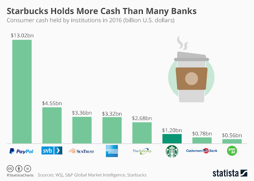

Not only do they hold more cash than many banks, but they also put geospatial data to excellent use. The simple notification that you are near Starbucks plants a seed in the consumer’s mind. Now, they can’t pass up that pumpkin spice latte on a crisp fall afternoon.
According to a recent study by Capco, customers are highly interested in text alerts and notifications about opportunities to transact more efficiently.
Banks can use Starbucks’ location-based strategy to send a message to your phone when you are near an ATM. This alert is especially helpful if it’s been a while since your last visit, and you might need to restock your wallet with cash.
Or, if you enjoy the buy now, pay later option, you might receive alerts for all the stores that accept this payment method during your next shopping spree.
Improve customer experience with personalized services
The future of financial services is here and more personalized than ever.
In the past, you might have had a relationship with your bank that was mainly transactional: you’d go in, deposit checks, withdraw cash from an ATM, maybe get a loan, or apply for credit. That’s all well and good — but it doesn’t give you the kind of personalized experience that we’re seeing more and more in fintech these days.
Nowadays, banks are looking to improve their customer experience by offering tailored services based on where you live, what kind of lifestyle you lead, and your spending habits.
With this information, they can offer different products or services based on what would be most helpful to each client individually — and ultimately build a foundation of loyal customers.
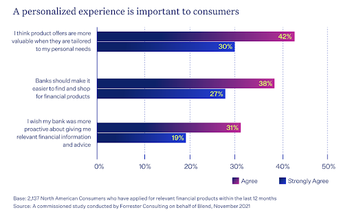
Consumers want an easy, streamlined experience with their bank. When customers receive offers for products that are contextually relevant, they’re more likely to engage with them. Regarding finding and shopping for financial products today, 65% of banking customers believe institutions should make it easier.

Geospatial data will become an integral part of customers’ experiences in the future as they interact with their financial institutions through mobile apps.
Fintech companies can use data about people and their assets to make better decisions about product development and deliver personalized marketing strategies.
Enhance fraud detection and prevention
With great power comes great responsibility. Fintech companies have access to a lot of data, and they’re using it in new ways to detect and prevent fraud.
For example, a bank uses geospatial data from its mobile app to determine the location of its customers. This data provides insight into how often customers use the app in certain areas, helping to indicate potential fraudulent activity.
So if someone is logging into their account from Moscow, Russia, instead of Los Angeles, California, for example, that could indicate a red flag — and adjustments are made to freeze the account until the transactions are approved or denied by the account holder.
Other fintech companies are turning to the dynamic duo, geospatial data and artificial intelligence, to create algorithms that detect money laundering based on behavioral patterns found within financial transactions.
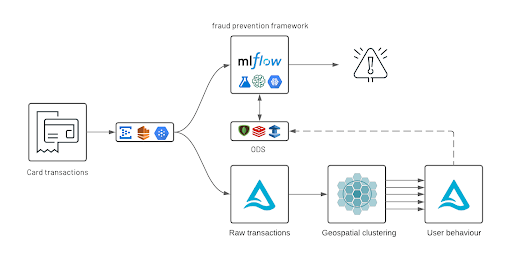

Geospatial data helps them identify specific areas where this activity occurs (think casinos), allowing them to focus their attention on one area instead of wasting resources elsewhere.
Add in the power of machine learning, and a computer can learn to identify fraudulent schemes from previously identified patterns and then decide whether to approve an ongoing transaction.
Geospatial data has a lot of potential for fintech, but one of the most precise ways it’ll revolutionize the way you bank is by enhancing fraud detection and prevention.
Wrapping up
The wants and needs of consumers are constantly evolving and, frankly, only becoming more demanding. We all want transparency, simplicity, and convenience in every aspect of our lives, including how we manage our money.
Geospatial data will improve banking services and fraud detection by showing how consumers spend their money in real-time. Add in the power of artificial intelligence and machine learning, and you won’t even recognize the banking industry anymore.
It pays to be a mover and a shaker.
Banks that quickly shift to investing in geographic information systems will set themselves apart from the crowd by creating a competitive advantage that’ll drive long-term business growth.


James es el jefe de marketing de Tamoco